Club’s map will assess UVic’s solar energy potential

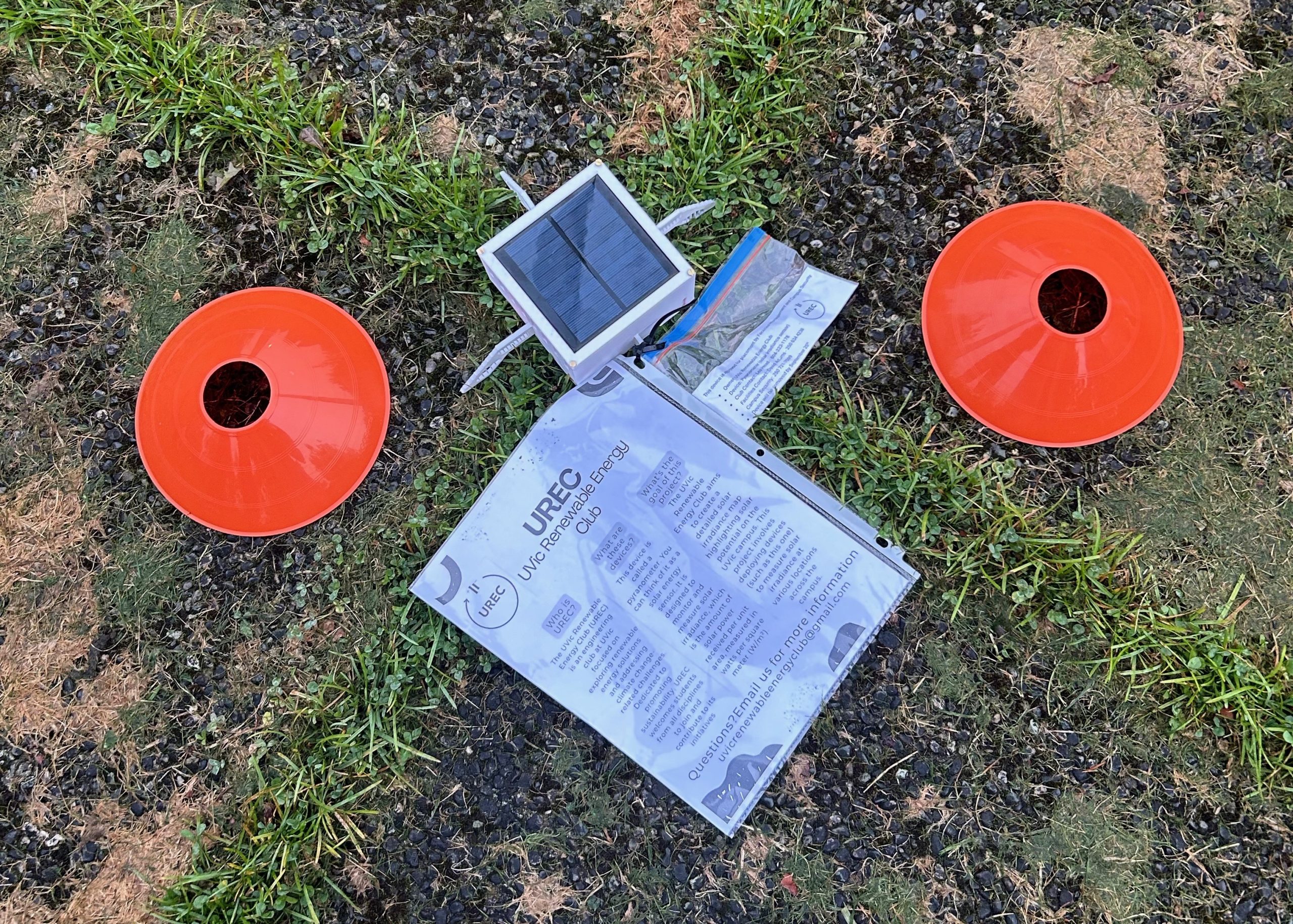
Photo courtesy of UVic’s Renewable Energy Club.
UVic’s Renewable Energy Club (UREC) is working to map UVic’s solar energy potential by measuring the amount of solar energy received in a number of key locations around campus.
By deploying solar sensors, known as pyranometers, around campus in September, UREC collected data on the solar irradiance — the solar power received per unit area — to determine the energy potential of those locations. The findings will be used to produce two maps: one that shows the 24-hour irradiance values on campus, with a slider to adjust for time of day, and another that displays the most optimal locations to collect solar energy.
After the map is completed, UREC plans to submit a review of the project and their analysis, along with an informal pitch to the university showing how their data and map can be used to capture sustainable energy on campus.
While region-specific solar irradiance maps can be accessed online, UREC member and mechanical engineering student Nate Shepherd said they often don’t account for factors such as tree coverage or shade from buildings, and typically don’t display daily fluctuations in solar irradiance, either. Using multiple pyranometers with hemispherical views allowed UREC to collect and discern between both direct sunlight and sunlight diffused by obstructions, such as trees, clouds, or even a passerby obscuring the sensor.
Shepherd said that, by continuously logging solar data at locations on campus over a period from sunrise to sunset, the map will display an exact solar irradiance reading over the span of a day to show the locations of the most optimized hot points at a given time.
UREC’s map will be created using a software called Mapbox, and should be available for public access as early as November.
The idea for the map came after UVic electrical engineering student Leo Head took over as president of UREC in May. Inspired by the pyranometer design of a former club member, Hussain Al Hassani, the group settled on the idea of creating a solar irradiance map of UVic’s campus.
“Our team wanted to build off his creation and take it one step further by developing a full map to quantify UVic’s solar potential,” said Head.
Emma Watson, a biomedical engineering student who manages the business side of UREC, said that sourcing the project’s funding required extensive outreach to groups like Young Canadians For Resources, who helped sponsor their work.
After funding was secured, the club moved forward with designing and producing the pyranometers required for data acquisition. Although the club had Hassani’s previous concept, Shepherd said they needed to simplify the design to make it cost-effective, so they could produce enough sensors. Head organized the redesign of the device, which consisted of a circuit board, a real-time clock to maintain time adjacent to the device’s readings, a battery, and a solar panel. These electronics are then enclosed within a 3D-printed box.
Shepherd, who designed and printed the box casing with UREC member Niko Linder, said they went through four different design attempts before finally mass-printing the final concept.
“The first one we realized was too big, and took too much spending on 3D-printed material.”
The design also needed to incorporate measures to mitigate any possible risks.
“We had to put things like vents [for fire safety] and labels on it, to make sure nobody was going to phone in thinking that it’s something that’s not right,” said Shepherd. “So it was a whole design process for us, which was really cool, to apply our engineering knowledge into a real-world concept that we designed.”
When it came to placing the devices around campus, Watson remembered the process as being almost comical.
“It’s super funny, because it’s 7 a.m. and you’re running around with what looks like robots, trying to get them out before everyone gets to campus.”
For four mornings in a row, the group met in dark UVic parking lots before briskly parting ways to distribute the pyranometers, along with orange cones and signage, to their selected locations for that day, before returning after sunset to collect them.
While the plan was to have ten sensors distributed around campus on a given day, one pyranometer was stolen from outside of the Jamie Cassels Centre.
Watson said that losing one sensor to theft was less than they anticipated.
Many of the other locations used for data collection were on rooftops of buildings, including MacLaurin, the Engineering and Computer Science Building, and Clearihue.
Shepherd believes there’s an opportunity for UVic to use more solar energy.
“I don’t think I’m aware of any energy capture on campus . . . I’ve never seen a solar panel up on the roofs [we accessed],” said Shepherd.
Though solar irradiance maps are most commonly used to evaluate how much power solar panels will receive, the information the maps provide about a location’s heat index from the sun can also be applied to other contexts, such as optimizing the cooling and HVAC requirements for a building during its construction.
UREC hopes their map will contribute to UVic’s sustainability efforts, and serve as an educational tool for both students and faculty interested in renewable energy and environmental sciences.
The club is looking for new student members to join as they prepare for the Solar Decathlon — an annual international competition in Colorado — this spring. UREC were semi-finalists at the previous Solar Decathlon in 2024.
Students can find out more information about the club on their Discord Server. A link to a website providing the campus solar irradiance map will be posted on the club’s Instagram page @uvicrec when the map is complete.


